Durobrivae from the Praetorium (Image – Peterborough Museum)
What is Durobrivae?
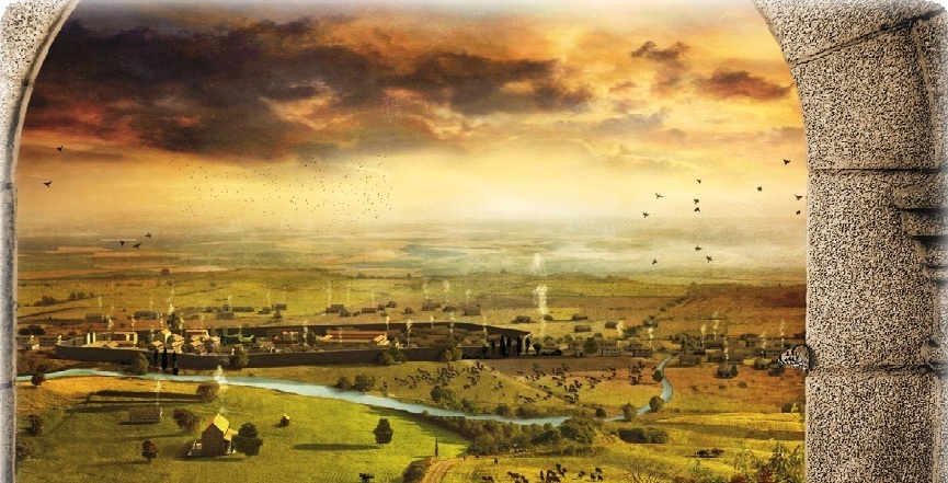
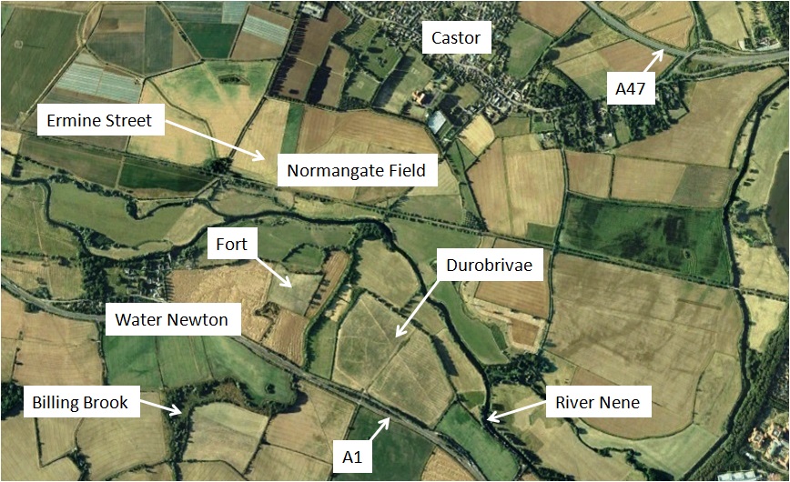
Durobrivae was a significant walled Roman town located near current day Peterborough. It grew up close to a Roman fort established to create and protect the crossing point of Ermine Street over the River Nene.
There were extensive potteries and iron works close to the town. There were also many Roman villas or farmsteads in the Nene valley region – and an impressive official building or Praetorium across the river at Castor. It is an essential part of early Peterborough history.
The name Durobrivae translates as fort by the bridge and first appears in the Antonine Itinerary of the late-second century; the route from Londinium (London) to Luguvalium (Carlisle) describes Durobrivas as 35 miles from Duroliponte (Cambridge) and 30 miles from Causennis (Ancaster).
A mortarium (pottery kitchen vessel) discovered at the nearby village of Water Newton bears a potter’s mark, Sennianus Durobrivis Urit (Sennianus of Durobrivae fired this).
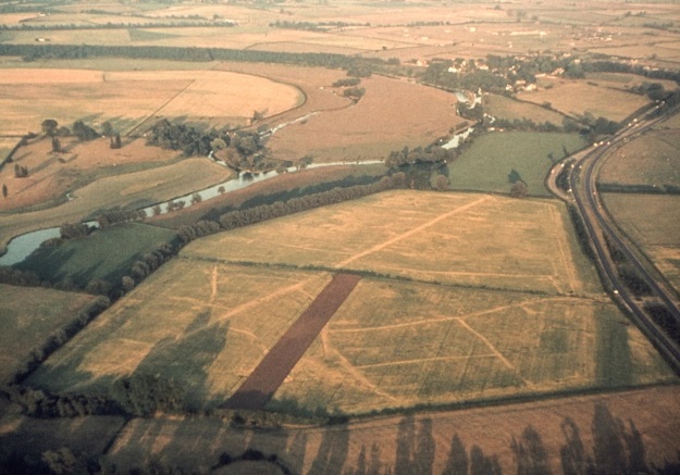
Durobrivae sits south of the River Nene on a stretch of land about 2km long and 1km wide. The walls and central street are still visible as bumps in a field close to the Great North Road (A1). Aerial photography has provided strong indications of the layout of streets and buildings within the town.
Durobrivae – Evidence & Finds
The most extensive excavations of Durobrivae were undertaken in the 1820s by Edmund Tyrell Artis who was steward to Lord Fitzwilliam at Milton. He identified buildings within the town, its suburbs and the wider area. By the standards of the time these were well recorded and in 1828 Artis published “The Durobrivae of Antoninus”, a volume of beautifully engraved plates of his excavations, illustrating the buildings, mosaic floors and many other artefacts he had discovered.
Apart from some limited excavations in the late 1950s, in advance of work to widen the A1, the site has been little disturbed since. It is scheduled under the Ancient Monuments and Archaeological Areas Act to be of national importance.
Aerial photography provides our best understanding of the site and has enabled detailed maps of the walled town and its suburbs to be made. The most striking feature is Ermine Street which runs through the centre of the town and is visible as a raised feature. The road network within the town seems largely to have grown organically as an irregular arrangement of side streets, though there may also have been some planned elements.
Durobrivae Satellite Image – Google 2006
Aerial photographs reveal not only the pattern of streets but also individual buildings in considerable detail. Houses or shops of varying size and plan line Ermine Street and the side streets. In the northern half of the walled town there are two substantially larger, possibly public, buildings.
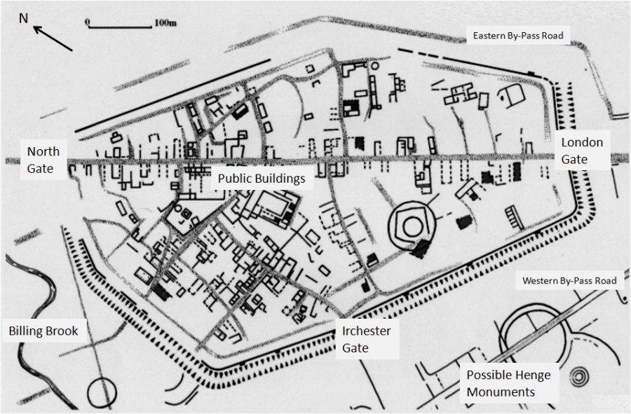
Durobrivae Town Plan – after Mackreth and Upex
The town wall with double or triple ditched defences is estimated to date from the late 2nd century. It encloses an area of about 20ha in the form of an irregular polygon with north, west and south gates. The wall survives as a low earthwork.
The fort just outside the walls of Durobrivae occupies a slightly raised spur of land surrounded on 3 sides by the River Nene and the Billing Brook. It would have been adjacent to the bridges over these rivers. An excavation of the fort site in 2012 suggests that it may only have been active for a matter of months.
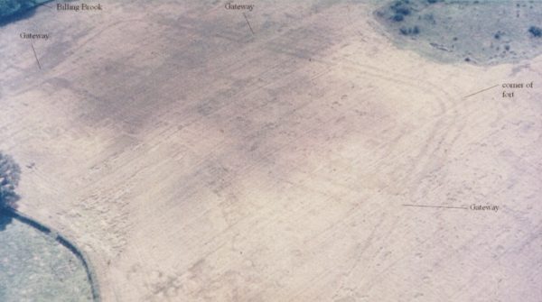
Roman Fort at Durobrivae (Stephen Upex)
There is no doubt that the walled town formed part of a much larger settlement. The suburban area immediately to the west of the walled town and Billing Brook is dominated by the pottery industry; many kilns have been identified, typically dating from the late 2nd to early 4th centuries AD. North of the river Nene there was an extensive and predominantly industrial suburb, now known as Normangate Field.
Where did Durobrivae “Fit”?
We know this was an important industrial area in pre Roman times and a number of circular features both within the town walls and to the south of the town point to prehistoric activity. The Water Newton Treasure discovered in 1975 dates to the late 3rd or 4th century and suggests a wealthy Christian community. It seems likely that as our knowledge of the site grows we will see evolution of the site from Iron Age right through to Anglo Saxon times.
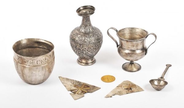
The Water Newton Treasure (Peterborough Museum)
The first Roman military presence in the area was at Longthorpe, nearer the modern centre of Peterborough. A fort was established there a few years after the 43AD invasion and this would have formed part of the northern frontier. Within about 30 years, as the route north was consolidated, a bridge over the Nene and its flood meadows was built to the west. It is likely that the fort at Durobrivae was directly associated with the construction and defence of this improved crossing – but may have been quite short lived.
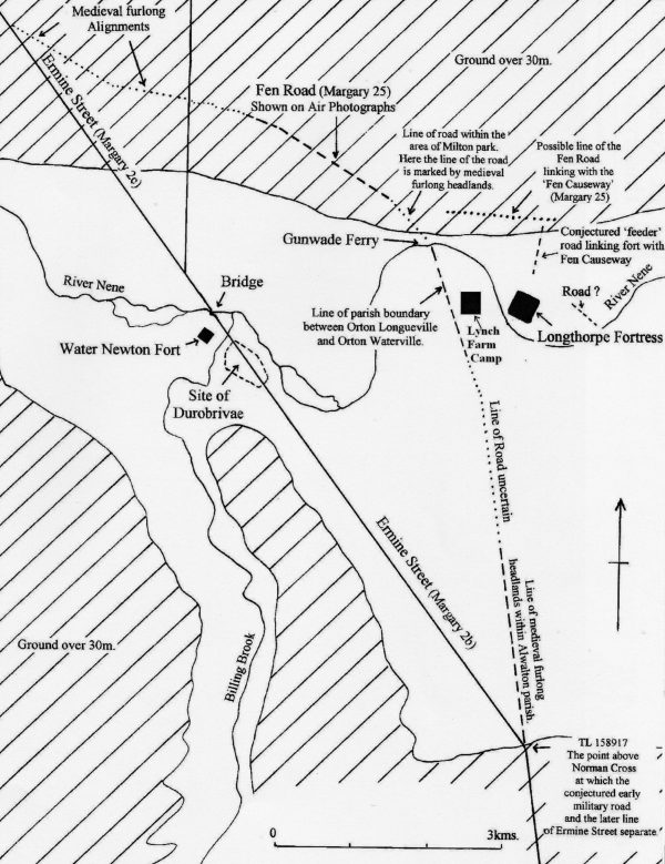
Realignment of Ermine Street and Roman Military Sites (Stephen Upex)
Durobrivae was a hub for transport routes in the east of Britain. It sat on the main north-south route, Ermine Street. King Street branched into Lincolnshire just north of the river Nene. The Fen Causeway provided a route east to Norfolk. The south west gate of Durobrivae was for the road to Irchester and ultimately to Wimbourne in Dorset (first established as a military route in about 45AD).
Whilst Durobrivae was categorised in Roman times as a “small town”, it is the largest town in this class. And the presence of public buildings and the extensive industrial suburbs indicate far greater scale and significance. It is also suggested that the huge Praetorium at nearby Castor was a major administrative centre for the fenland area.
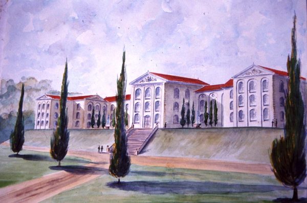
Castor Praetorium – Artist’s Impression (Stephen Upex)
The fine pottery produced in Durobrivae and its suburbs from the 2nd to the 4th century is known as Nene Valley Colour Coated Ware (or Castor Ware). It is prevalent in the Fens but is found across much of Britain. Grey wares and mortaria were also produced in volume.
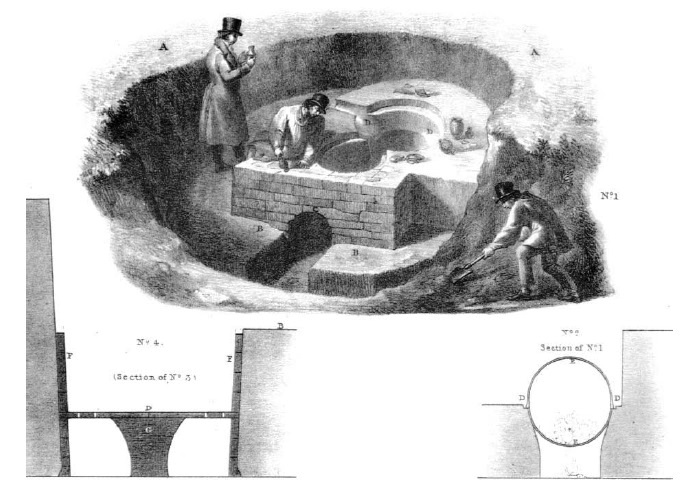
Roman Kiln – Engraving from Artis’ ‘Durobrivae’
Why is Durobrivae Important?
Durobrivae itself is a significant Roman town which has been little disturbed either by modern construction or by excavation. Along with its hinterland, which is rich in agricultural and industrial sites, there is scope to develop a new level of understanding of urban growth and economics during the Roman period.
A major initiative to extend our understanding of Durobrivae is underway. It is hoped that funding can be obtained to undertake a series of minimally invasive surveys of both the town itself and the surrounding areas. This will be undertaken through a combination of professional and amateur archaeologists.
More Information about Durobrivae
Nene Valley Archaeological Trust
The Nene Valley in Prehistoric and Roman Times – Andrew Nash

