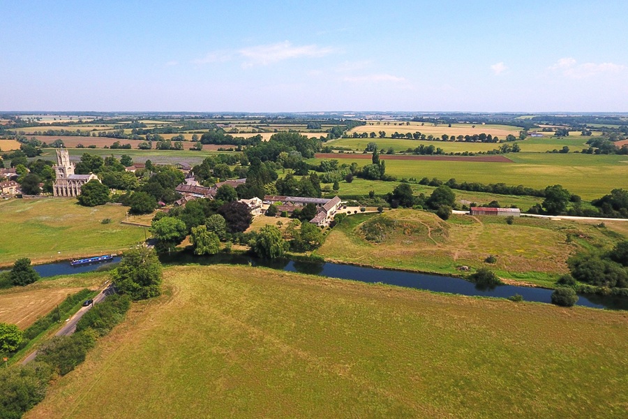
What is Fotheringhay Castle?
Located 5km from Oundle and 14km from Peterborough, Fotheringhay Castle has had an illustrious history. It was originally a Norman motte and bailey castle topped by a timber keep. For 500 years it was directly linked to the royal families of both England and Scotland. The buildings have long gone but the castle mound and adjacent lumps and bumps clearly signal its former site.
There is a strong historical record. Whilst many similar castles fell out of use, Fotheringhay was instead remodelled as a “palace-fortress” by Edmund Langley, first Duke of York. It remained an administrative centre for the House of York and its extensive midland estates.
The castle had many high-profile residents and visitors. By the mid-16th century Queen Elizabeth I found it old fashioned but it was a convenient place for the trial and execution of her cousin, Mary Queen of Scots.
Fotheringhay remained a royal castle until 1603 then passed through various owners and was demolished by the early 18th century.
The site is protected as a Scheduled Monument and is accessible to the public.
Fotheringhay Castle – Evidence & Finds
The site of the castle is clear but the detail of its construction and its evolution less so.
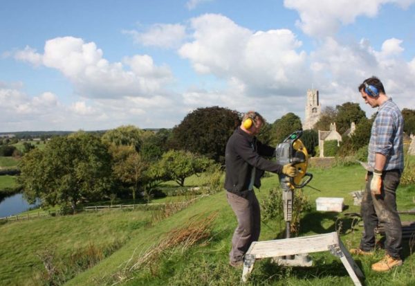
The Round Mound Project coring of the motte in 2015 dated it to mid/late 11th to late 12th century
Lidar and Geophysical Survey
The castle mound (motte) stands 7m high and about 70m in diameter; the top is flattened and about 30m across with an irregular surface, indicating the remains of the stone keep. A ditch up to 4m deep and 20m wide is visible on the north and west sides of the motte. Originally this ditch is thought to have encircled the mound. A ditch of similar size surrounds the inner and outer bailey areas. The inner bailey is sub-rectangular and measures about 50m x 65m and retains traces of an earthen rampart.
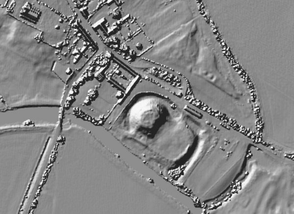
LiDAR Map (DSM) including Fotheringhay Castle, the Church, and River Nene. Image Credit – ARCHIUK
The castle is depicted on a map of about 1640 with the main buildings forming a neat quadrangle around the curtain walls of the inner bailey. However, this may well owe more to artistic licence than reality. Geophysical surveys undertaken in 1991 and 2018 suggested a number of discrete, but linked, buildings.
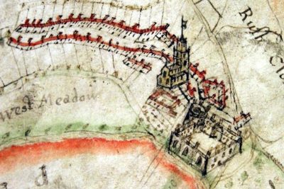
The castle as shown on the Cliffe Bailiwick map
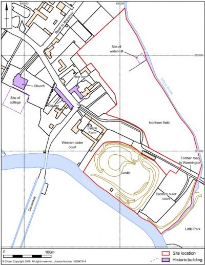
Location map showing the extent of the 2018 survey
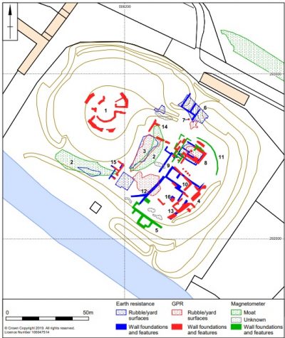
Interpretation of geophysical anomalies by survey method on the motte and in the inner bailey
The survey discovered the stone foundations of the inner and outer walls of the keep [1] surviving at a depth of about 1m. Within the inner bailey the buildings appear to comprise two main ranges [8 and 10] with a smaller building linking them [9]. Interpretation is difficult in that there are extensive rubble surfaces which may represent demolition and infilling which mask other structures.
The only visible stone remnant of the castle is a large block of masonry which in 1911 was stood upright and surrounded by protective iron railings by the Peterborough Archaeological Society [black square on plan]. The block is thought to have tumbled or been moved to its current position from either the motte or elsewhere in the bailey.
The Historical Record
Domesday recorded Fotheringhay as being the property of Countess Judith, niece of William the Conqueror and widow of the Earl of Huntingdon. There were 25 tenants, 19 villeins, 6 borders, 3 slaves and a priest. It was Judith’s son-in-law, Simon de Senlis, Earl of Huntingdon and Northampton, who built the first castle. Its original form would have comprised a conical mound encircled by a protective bank and ditches and topped by a timber keep. It would have been approached through a wide enclosure (the bailey) with secondary buildings such as stables and workshops.
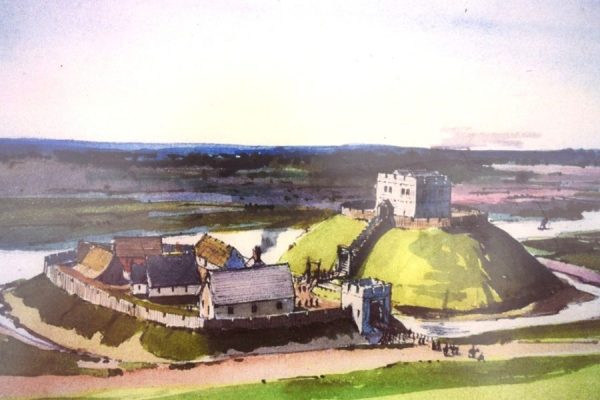
Reconstruction of Norman Fotheringhay Castle. Image Credit: Terry Ball, English Heritage
The castle was enlarged and rebuilt in the late 14th century by Edmund Langley, son of Edward III, and it is thought that a large two-storey lodgings block on the motte (the Fetterlocks), the outer bailey, and the infilling of the east side of the motte ditch date from this period . Records indicate that in 1341 a stone tower stood on the motte, and within the inner bailey were two chapels, a great hall, chambers and a kitchen. A gatehouse stood beside a drawbridge over the inner bailey ditch. A group of buildings known as The Manor lay northwest of the motte on the site of the current Castle Farm.
Edmund and his son, Edward, established a college of priests in the castle in the late 14th century; in 1411 this college was transferred to the parish church which was rebuilt on a grand scale.
Fotheringhay was regularly visited by royalty during the tumultuous highs and lows of the next century. Richard III was born at Fotheringhay in 1452. Edward IV was responsible for improvements and by 1476 he had built the New Inn in the village to supplement accommodation for visitors. In 1505 Lady Margaret Beaufort had 39 chambers redecorated for her household. King Henry VIII gave Fotheringhay to his wives in succession.
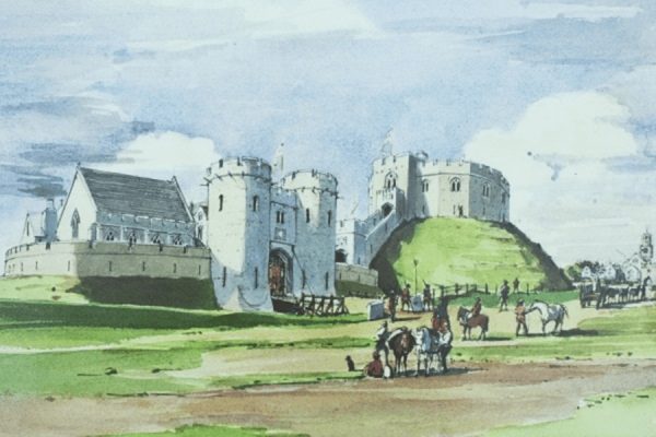
Reconstruction of Fotheringhay Castle by the 15th Century. Image Credit: Terry Ball, English Heritage
The castle fell out of use in the late 16th century and it was granted by King James I to Sir Edward Blount, passing out of royal ownership. A 1625 description gives a flavour of the grand residence it had once been:
The gate and forepart of the house fronts the N, and as soon as you are passed the drawbridge, at the gate there is a pair of stairs, leading up to some fair lodgings and up higher to the wardrobe, and so on to the fetterlock on top of the mound on the NW corner of the castle, which is built round of 8 or 16 square with chambers lower and upper ones roundabout, but somewhat decayed and so are the leads on the top; in the very midst of the round yard in the same there has been a well, now landed up. When you come down again and go towards the hall, which is wonderful spacious, there is a goodly and fair court, within the midst of the castle. Of the left-hand is the chapel, goodly lodgings, the great dining-room, and a large room at this present well garnished with pictures. Near the hall is the buttery and kitchen; and at the other end of the kitchen a yard, convenient for wood and such purposes, with large brewhouses and bake-houses and houses convenient for offices. From the gate going out of that yard, there is another yard half-encompassing the castle, going roundabout to the first gate and a great barn in the W. side of the said yard. A gate-house and another ruinous house in the E. corner of the same.
The castle was abandoned in the 17th century and a gradual process of demolition of all its walls and buildings was largely completed by the early 18th century. The few remaining building fragments still standing by the late 19th century were incorporated into the barns of the present Castle Farm by then owner Lord Overstone who also filled in the former moat on the west side of the site.
Was there once another Fotheringhay Castle?
LiDAR images reveal a circular earthwork overlain by ridge and furrow 300m to the southeast of Fotheringhay Castle.
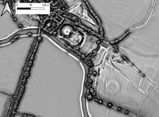
LiDAR (DSM, 1m) enhanced for archaeology Image Credit – Environment Agency
Interpretation of this feature is uncertain. Some have suggested it is the remains of a Neolithic henge monument. Others argue that it may be a ringwork set up in the late 10th -11th century, defending the river crossing and providing security for the local Saxon thane: or perhaps it marks the site of a 12th century siege castle.
Where did Fotheringhay Castle “Fit”?
At one level, Fotheringhay was a large but fairly typical motte and bailey castle. There are over 450 recorded in England – many of them built by the Normans to protect river crossing points.
Geographically, Fotheringhay may seem an obscure backwater today but in the Medieval period it would have had greater significance. Peterborough and Oundle were important centres and there was a (now lost) north-south road running through the castle site; this road headed across the Nene valley to Warmington and would have formed part of an alternative route from Alconbury to Stamford.
Politically, Fotheringhay was at the heart of the Yorkist powerbase through the 14th and 15th centuries. Set within a productive agricultural area and close to the hunting grounds of Rockingham Forest.
The economic fortunes of Fotheringhay rose and fell with those of the castle. In 1524 the village had over 100 families (similar to King’s Cliffe). Deprived of its castle and college the village became a modest agricultural settlement and by 1801 there were only 57 families.
Antiquary, John Nichols, observed that:
Fotheringhay has been distinguished beyond any other place in Britain, except the Capital, by the aggravated misfortunes of Royalty.
Why is Fotheringhay Castle Important?
The castle is more important for its historical associations than for the earthworks themselves. The castle’s rich history is perhaps best epitomised by two notable events.
The future Richard III was born at Fotheringhay in 1452. He lived at the castle for the first 6 years of his life. Shakespeare made much of his infamous rise to the crown and in particular the death of his 2 nephews in the Tower of London. He went on to wage war with the rival Lancaster family, eventually losing to Henry Tudor at the Battle of Bosworth Field in 1485. His story is comprehensively told at the King Richard III Visitor Centre in Leicester where his body was discovered in 2012.
Mary Queen of Scots was brought to Fotheringhay Castle in September 1586 having sought sanctuary in England 18 years before. Accused by Elizabeth’s advisors of conspiracy with the French she was tried for treason at Fotheringhay. Chief of Elizabeth’s advisors was William Cecil who had recently built his first great family residence at Stamford. Mary was found guilty and then beheaded in February 1587. Her body was removed and buried first at Peterborough Cathedral but then relocated to Westminster Cathedral by her son James I in 1612.
More Information about Fotheringhay Castle
Aerial and geophysical surveys at Fotheringhay Castle, Castle Studies Trust, 2019
Top of page aerial photo from south. Image Credit: Rex Gibson